OUR FLEET
Professional Drone Inspection Services
TAG Droneworks operate a high-performance drone fleet designed to meet the diverse needs of New Zealand’s agricultural, forestry, industrial, and creative sectors. Each drone in the fleet is chosen for its unique capabilities, allowing TAG to deliver tailored aerial services - from high-volume spraying and granular spreading to precision mapping, specialist inspections, and cinematic media production.
Whether working in rugged hill country, tightly planted orchards, remote forestry blocks, or high-end promotional environments, TAG’s fleet combines cutting-edge technology with deep operational expertise. Here’s a detailed look at each drone and how it contributes to TAG’s mission of ethical, solution-focused service.
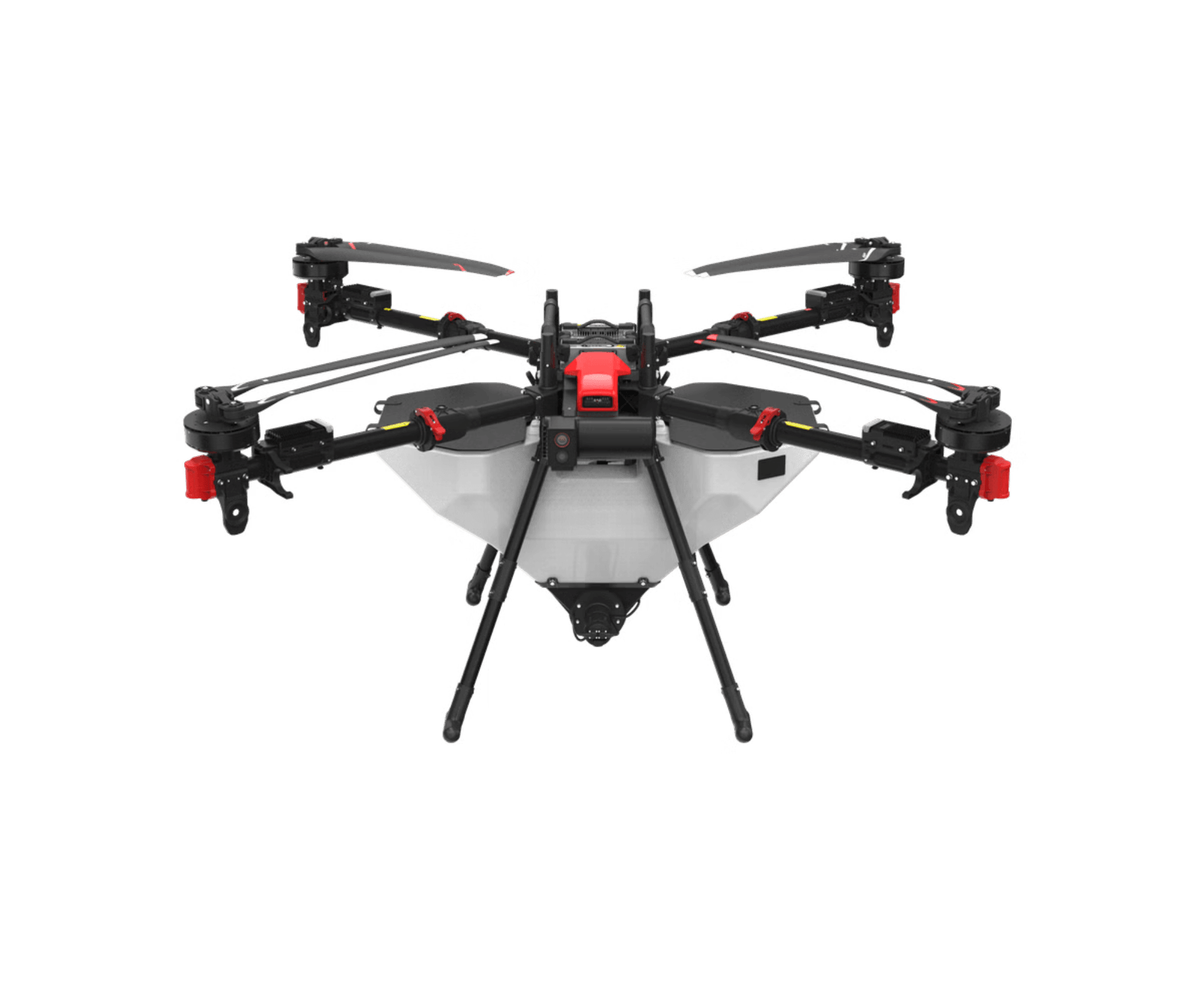
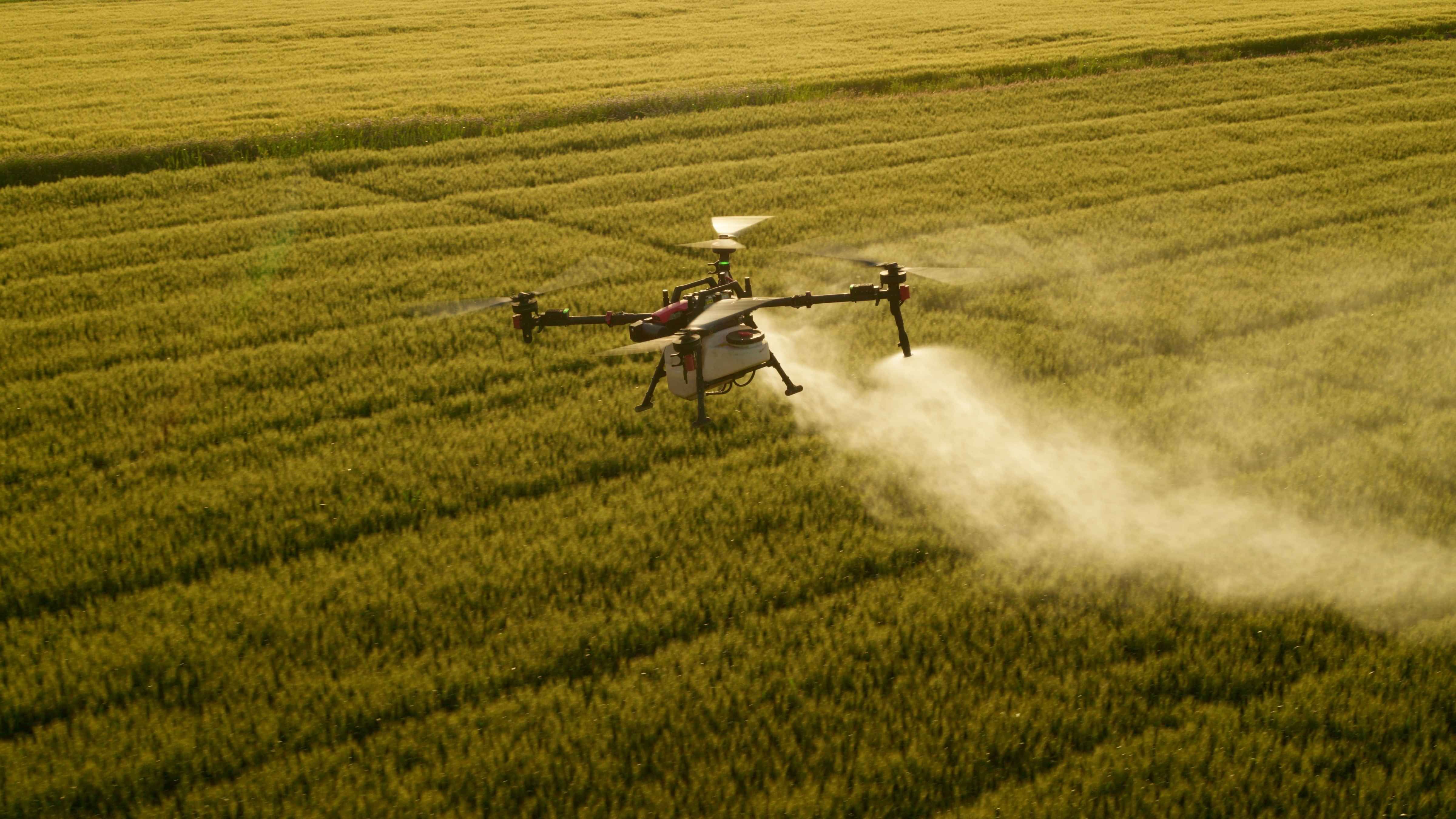
XAG P150 Agricultural Drone
High-volume application with RTK precision and terrain adaptability.
The XAG P150 is the backbone of TAG Droneworks’ agricultural operations. Designed for serious aerial work, it features a 70-litre spray tank and a flow rate of up to 30L/min, making it ideal for large-scale spraying tasks such as pasture management, selective herbicide application, and orchard treatments. Its dual atomising nozzles produce ultra-fine droplets, reducing drift and improving coverage—critical for protecting waterways, native bush margins, and sensitive crop zones.
For granular applications, the P150’s RevoCast system can broadcast up to 230kg of fertiliser or seed per minute. This capability is especially valuable for topdressing hill country, re-seeding erosion-prone slopes, and restoring land post-harvest or forestry operations. The vertical waving spreader improves wind resistance and ensures even distribution, even in gusty conditions.
A standout feature of the P150 is its RTK (Real-Time Kinematic) positioning system, which enables centimetre-level flight accuracy. Combined with terrain-following radar and RealTerra 3D mapping, the drone autonomously adjusts flight paths and application rates based on slope, vegetation density, and prescription maps. This ensures safe, consistent coverage across New Zealand’s varied topography - from the flat Canterbury plains to the steep ridgelines of Hawke’s Bay.
TAG uses the P150 extensively for gorse and wilding pine control, enabling precise herbicide application in remote or sensitive areas without disturbing surrounding vegetation or requiring ground crews. While the P150 is not a camera drone, its integration with mapping platforms ensures that every application is informed by accurate geospatial data.
XAG P150 Agricultural Drone
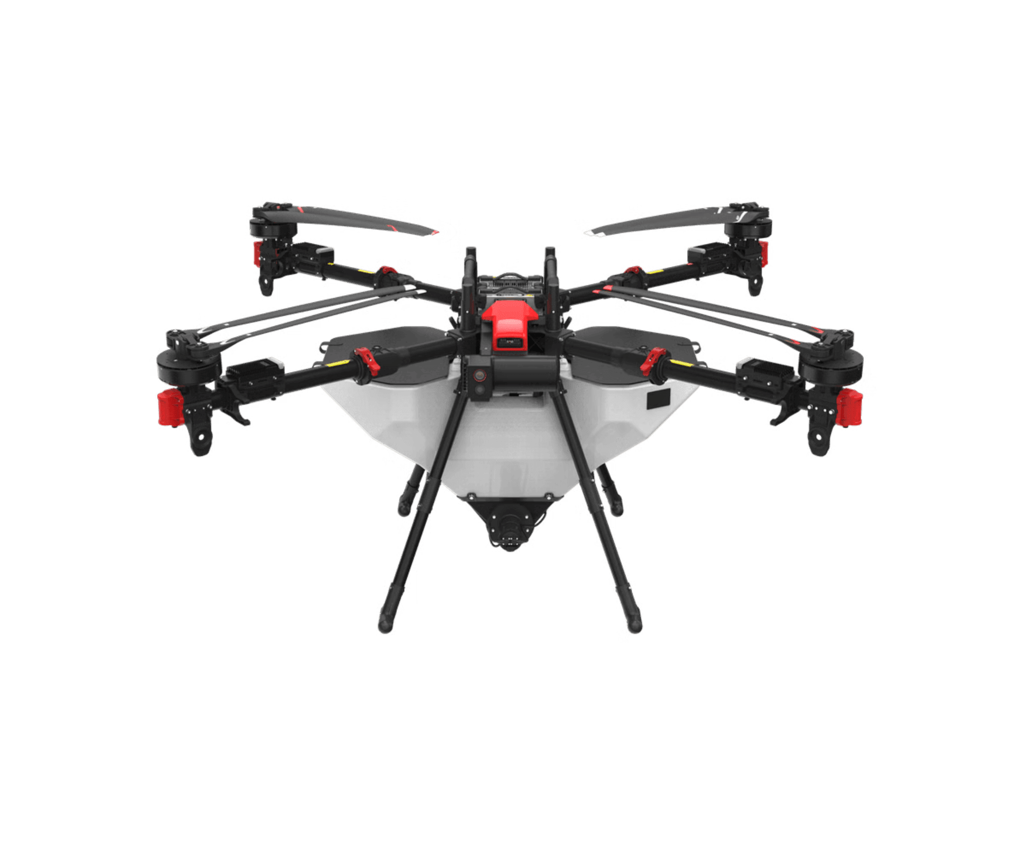
Specifications
High-volume application with RTK precision and terrain adaptability.
The XAG P150 is the backbone of TAG Droneworks’ agricultural operations. Designed for serious aerial work, it features a 70-litre spray tank and a flow rate of up to 30L/min, making it ideal for large-scale spraying tasks such as pasture management, selective herbicide application, and orchard treatments. Its dual atomising nozzles produce ultra-fine droplets, reducing drift and improving coverage—critical for protecting waterways, native bush margins, and sensitive crop zones.
For granular applications, the P150’s RevoCast system can broadcast up to 230kg of fertiliser or seed per minute. This capability is especially valuable for topdressing hill country, re-seeding erosion-prone slopes, and restoring land post-harvest or forestry operations. The vertical waving spreader improves wind resistance and ensures even distribution, even in gusty conditions.
A standout feature of the P150 is its RTK (Real-Time Kinematic) positioning system, which enables centimetre-level flight accuracy. Combined with terrain-following radar and RealTerra 3D mapping, the drone autonomously adjusts flight paths and application rates based on slope, vegetation density, and prescription maps. This ensures safe, consistent coverage across New Zealand’s varied topography - from the flat Canterbury plains to the steep ridgelines of Hawke’s Bay.
TAG uses the P150 extensively for gorse and wilding pine control, enabling precise herbicide application in remote or sensitive areas without disturbing surrounding vegetation or requiring ground crews. While the P150 is not a camera drone, its integration with mapping platforms ensures that every application is informed by accurate geospatial data.
DJI Mavic 3 Enterprise
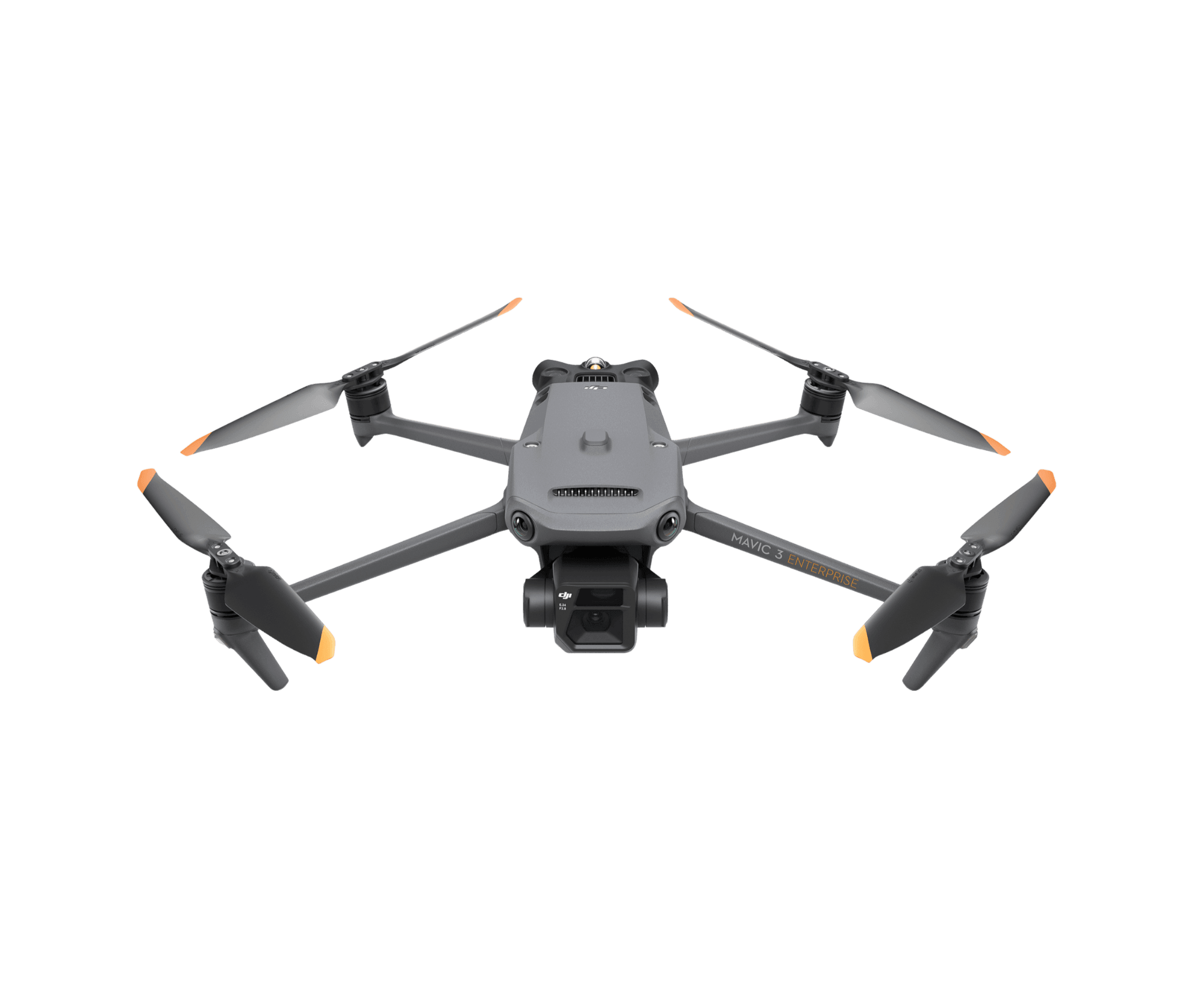
Specifications
Precision mapping, terrain modelling, and visual data capture.
The DJI Mavic 3 Enterprise plays a critical support role in TAG’s operations, particularly in mapping and planning missions for the XAG P150. It features a 20MP wide-angle camera with a mechanical shutter, allowing for distortion-free ortho-mosaic mapping and accurate photogrammetry. The camera captures 4K video at 30fps and JPEG/RAW stills, making it suitable for both technical and visual documentation.
Its RTK module enables centimetre-level positioning accuracy, which is essential for generating elevation models, crop health overlays, and terrain maps. These maps inform flight planning and application zones for the P150, ensuring that every spray or spread job is based on precise, up-to-date data.
Beyond its support role, the Mavic 3E is a powerful standalone tool. TAG uses it to gather information for clients to undertake:
Pasture biomass assessments
Weed identification and mapping
Infrastructure inspections
Forestry block monitoring
Environmental compliance documentation
Its compact size and rapid deployment make it ideal for fast, efficient data collection across farms, orchards, and industrial sites. The drone’s zoom capabilities and obstacle avoidance allow it to operate safely in complex environments, including under canopy or near structures.
Image quality is a key strength. The Mavic 3E’s camera delivers sharp, high-contrast imagery suitable for analysis, reporting, and client documentation. Whether capturing a wide paddock or zooming in on a fence line, the results are clear, consistent, and actionable.
DJI Inspire 2
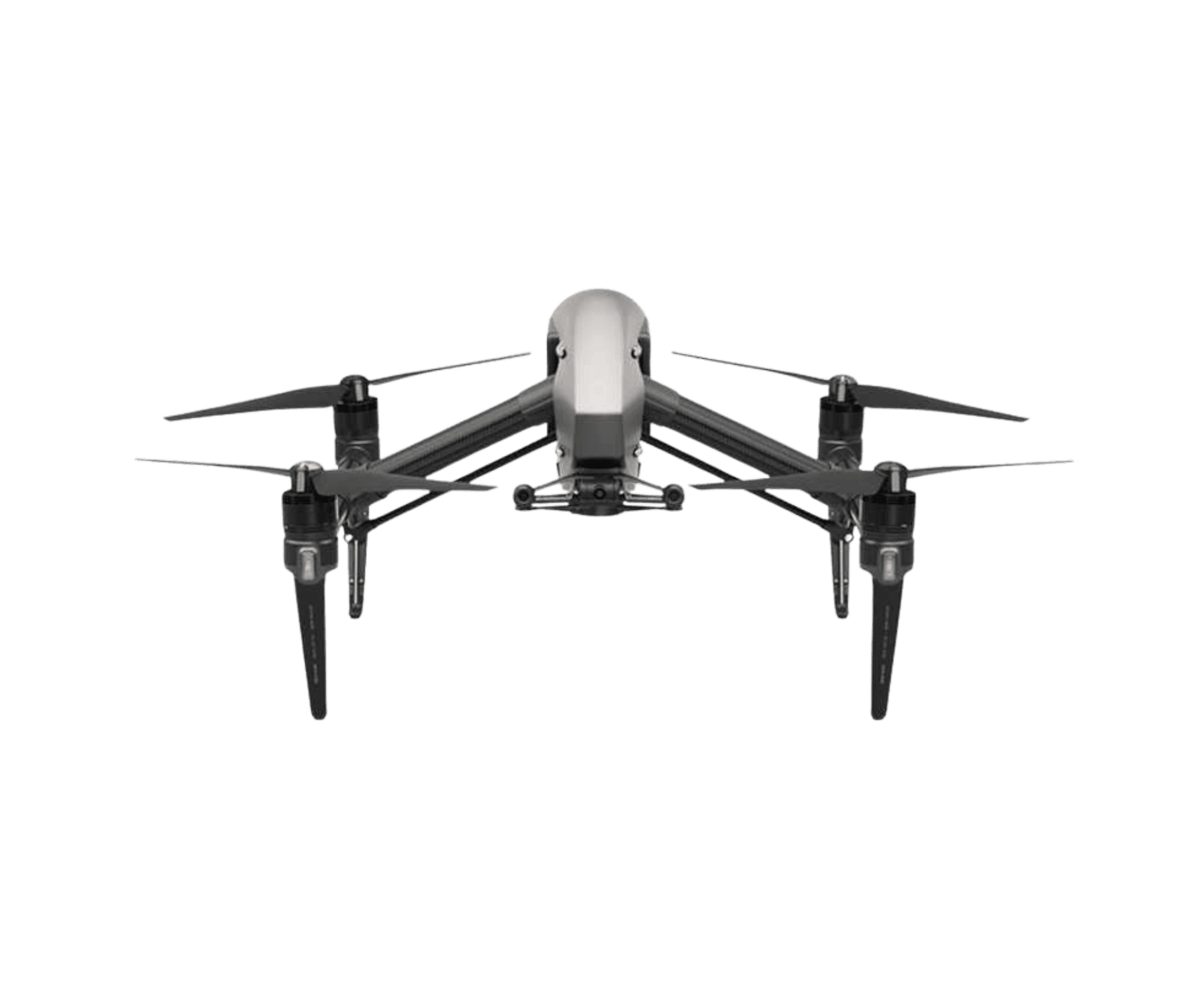
Specifications
Cinematic storytelling with professional-grade image formats.
For projects requiring high-end visual media, TAG deploys the DJI Inspire 2, a cinematography drone capable of recording in CinemaDNG and Apple ProRes RAW formats. These industry-standard codecs allow for maximum flexibility in post-production, preserving colour depth, dynamic range, and detail for broadcast-quality results.
The Inspire 2 is equipped with the Zenmuse X7 camera, which supports interchangeable DL lenses and offers 6K video recording and 24MP stills. With 14+ stops of dynamic range, it excels in challenging lighting conditions, capturing everything from golden-hour landscapes to low-light forestry scenes with cinematic clarity.
TAG uses the Inspire 2 for:
Brand storytelling and promotional content
Documentary-style videography
Client showcases and operational footage
Training and marketing assets
Dual-operator control allows one pilot to manage flight while a second operator controls the camera, enabling complex tracking shots and dynamic framing. The drone’s Lightbridge 2 transmission system provides reliable live view and control, while its obstacle sensing and flight autonomy features ensure safe operation even in complex environments.
Image quality is where the Inspire 2 truly shines. Footage is rich, detailed, and colour-accurate - ideal for editing, grading, and publishing across platforms. Whether capturing drone spraying in action or sweeping views of a beach at sunrise, the Inspire 2 delivers visuals that elevate any project.
DJI Mini Pro 4
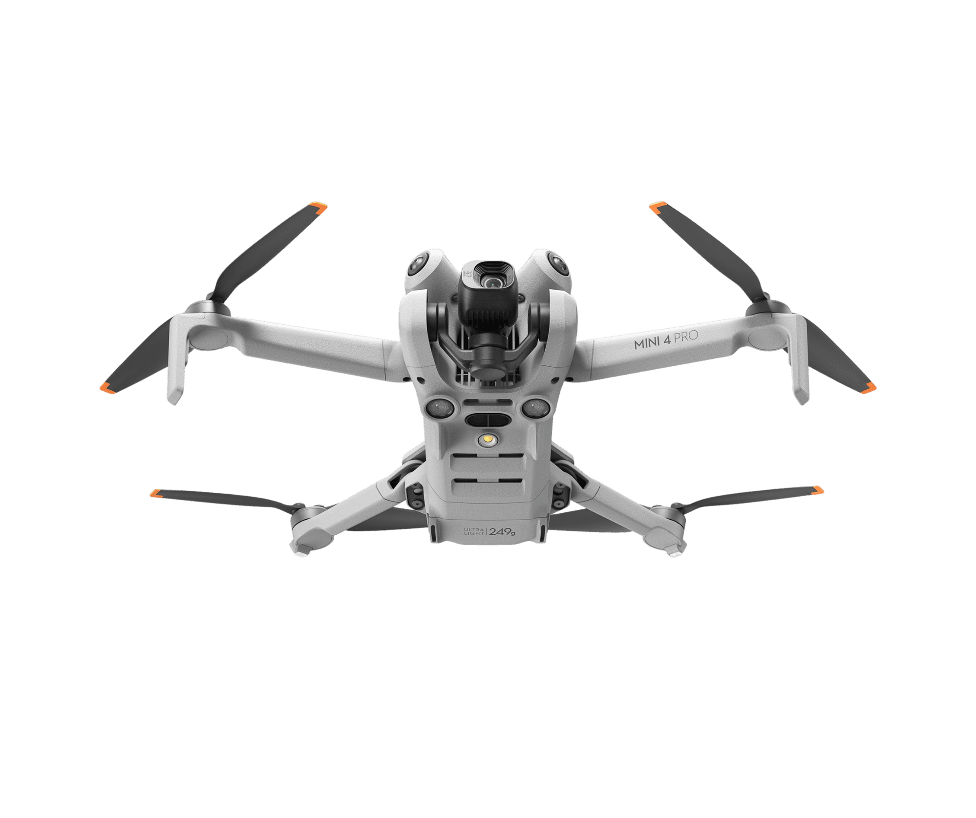
Specifications
Agile inspections and high-quality content in a compact form.
Rounding out the TAG Droneworks fleet is the DJI Mini Pro 4, a lightweight, ultra-portable drone used for specialist tasks where agility and discretion are key. Despite its compact size (under 249g), it offers impressive image quality with 4K/60fps video, HDR support, and RAW stills.
TAG uses the Mini Pro 4 for:
Quick site inspections
Infrastructure checks
Progress documentation
Behind-the-scenes content
Social media updates
Supplementary aerial footage
Its small footprint allows it to operate in tight spaces, indoors, or near people and livestock without causing disruption. The drone’s O4 transmission system ensures stable connectivity, while its 45-minute flight time supports extended missions without frequent battery swaps.
Image quality is surprisingly strong for its size. The Mini Pro 4 captures crisp, vibrant footage with good dynamic range and detail—ideal for web content, client updates, and visual reports. It’s also a valuable scouting tool, helping TAG verify conditions and plan larger missions with minimal setup.
Integrated Fleet Operations
Precision, flexibility, and visual impact across every mission.
Together, TAG Droneworks’ fleet offers professional drone inspection services with a full spectrum of aerial capabilities. Each drone is selected not just for its technical specs, but for how it fits into a broader operational strategy. By combining high-volume application, precision mapping, cinematic media, and agile inspection tools, TAG delivers services that are:
Technically precise – using RTK, terrain-following, and smart automation
Environmentally responsible – reducing chemical use, fuel consumption, and ground disturbance
Visually compelling – producing high-quality media for clients and stakeholders
Operationally efficient – minimizing setup time, maximizing coverage, and adapting to terrain
Whether it’s spraying pasture, controlling invasive species, mapping forestry blocks, or producing high quality promotional content, TAG Droneworks brings together technology and expertise to deliver results that are accurate, efficient, and tailored to the land.
With a deep understanding of New Zealand’s landscapes and industry needs, TAG is committed to ethical, solution-focused service - helping farmers, foresters, land managers and creators make smarter decisions and achieve better outcomes.

Aerial drone services for farming,
forestry, and infrastructure
Get in touch
Graeme Joy
graeme@tagdroneworks.com
Mobile: 027 442 0000